

Since the railways are uninterrupted, they give us a surprise horizon line in the dense housing stock
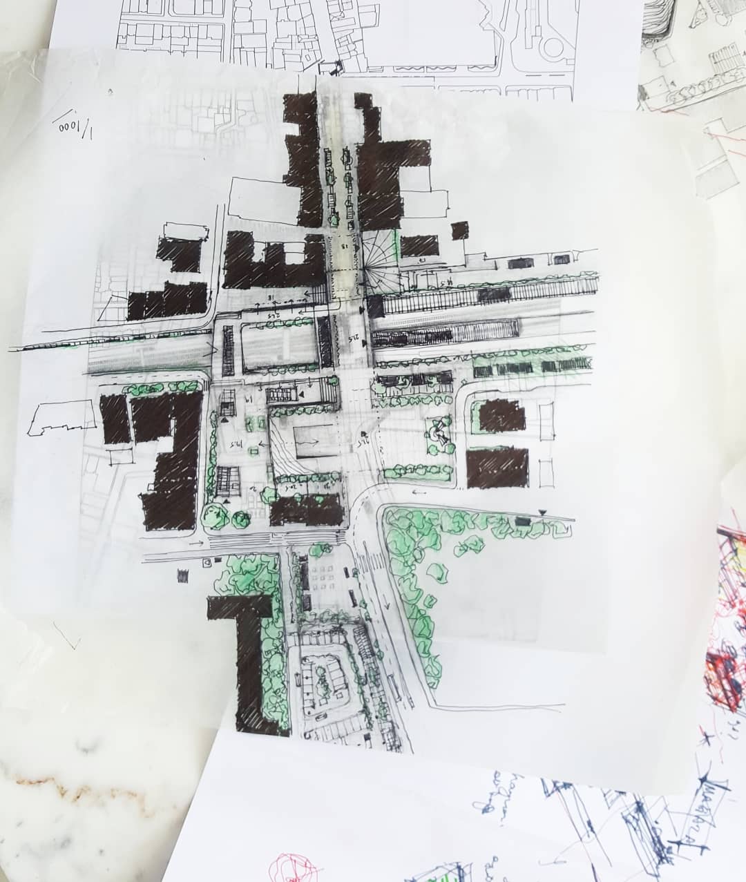
BAKIRKOY CUMHURIYET SQUARE
#competition, #urbandesign, #bakırköy, #museum, #architecture, #red
Information
BAKIRKOY CUMHURIYET SQUARE
Our arrivals to Bakırköy always take place in the footsteps of history ... If you come by sea, a cistern from the Magnaura Palace will welcome you, and if you come by train, you will pass through the same rails with dozens of generations and get off at the same point. Istanbul Street, where you pass by vehicle, is the two thousand-year-old Via Etnagia itself.
The cognitive expression of spatial knowledge is closely related to what they carry from the past to the present and what kind of a trace it will leave for the future. This relationship between urban space and urban memory is the basic structure of the local life that connects with the urban texture. The change of life styles also shapes the spaces. This interaction paves the way for a spatial transformation and causes the relationship between individuals and space to differ.
Although the project area is defined as Cumhuriyet Square and Fahri Korutürk Street, which is the natural extension of this square, we see that we are faced with a macro-scale issue when considering the cross-scale situation of the context, the history of the region, its transformation and memory codes. The proposal project is to realize the situation of Bakırköy with its history by the citizens, to make it a part of daily life and to design the area to form the backbone of a cultural route. In this context, the project area has been considered as a culture conjunction.
Client
İstanbul Metropolitan Municipality
Location
İstanbul
Size
50500 sqm
Awards
1st (Equivalent) Prize
People's Choice - 1st Place
Program
Urban Design
Status
National Competition
Collaborators
Şeyma KAHRAMAN (Landscape Architect)
Gizem ÖZBABA (Urban Planner)
Naz AKDEMİR
Sena Şeyma CAN
Ömer Tunahan LİMONCU
Culture Conjunction

URBAN LAYOUT
The planning to be made in the project area should be considered only as a beginning and macro-scale decisions supporting this context at the city scale should also be taken into account. The absence of other nutritious decisions on an urban scale, puts the project site at risk of not going beyond an small open space arrangement. With this concern in mind, the city was handled on a macro-scale and the competition area was designed as a part of a cultural route and secondary intervention areas were recommended to strenghten the connection of the route with the city.
Before starting the spatial design of the project area, the accessibility fiction in the urban memory track was discussed together with the environment of the area. The proposal project is shaped over the idea of a cultural route in order to recognize and adopt the situation of Bakırköy in touch with history by the citizens and to make it a part of the normal flow of daily life. Culture Route is an uninterrupted pedestrian promenade starting from the coastal line and extending to Fildami Cistern. Ebuzziya - Fahri Korutürk Streets and Cumhuriyet Square where it comes into contact with daily life. The cultural route not only touches historical buildings and ruins, but also touches memories. In this context, the railway has been considered as an important memorial space, both as a very strong threshold that separates the square from the southern part of the city, and with its extremely strong reference in the memory of the people of Bakırköy.
Train tracks make us stop. They sometimes invoke a farewell and sometimes an expected reunion. That's why we stop when we see a train, it contains a sad nostalgia in its ontology. Since the railways are uninterrupted, they give us a surprise horizon line in the dense housing stock. The land that these tracks step on is the same land people have been using for hundreds of years. In this context, the railway is the place where the cultural route is the most powerful space. This route relates to the railway in various ways. It goes down next to the railway, rises above it, becomes a platform and presents the city a viewing point overlooking the horizon.
Our arrivals in Bakırköy always take place in the footsteps of history


GROUND FLOOR USAGE ALTERNATIVES – FAHRİ KORUTÜRK STREET
Fahri Korutürk Street, which extends from Bakırköy Cumhuriyet Square to the coast, is the main axis of the district center. In this context, the ground use of the street consists largely of shops of various sizes, telecommunication areas, exchange offices and banks. In addition to commercial spaces, business inns and passages with direct entry from the street are constantly operating as pedestrian generators of the street. The axis, which is used extensively today, creates a negative image with the irregularity and discontinuity of urban furniture, lack of green areas and shading areas, insufficiency of lighting units and incompatible floor materials. At the same time, the billboards on the facades of the buildings, neglected showcase areas and the signage density, which is noticeable especially in business inns, are considered as areas that need to be intervened.
In the proposed project, ground floor usage functions are discussed under 5 main headings and a function band is proposed in front of each building. These areas are leasable areas and have the potential to be transformed according to the changing ground floor functions.


A public square defined with public facilities in the third dimension


CUMHURIYET SQUARE
In the current situation, the square is far from being a public place to stop and spend time, it is just a plane to pass by. One of the important reasons for this problem can be summarized as the weak connection between the southern part of the city and the square, the arc that turns around the square has a separating effect rather than a descriptive one, and there is no function group that requires standing in the square. This disconnection was eliminated with the re-established, an important threshold, the railway, and the cultural route, which establishes various spatial relations in different sections.
Despite the possibility that the arcade surrounding the square has penetrated into the urban memory, the boundaries of the square are defined with trees, and the verticality in the memory is met with trees. In order for the square to become a living public space, public facilities that both have a descriptive and scaling effect in the third dimension are designed.


Related Projects
The revitalization of the “Sports” Code that is currently in the memory of the project site
A Dynamic Flag form standing in between the state and the public


İstanbul (HQ)
Caferağa Mahallesi 34347 | Moda-Kadıköy
info@kaat.co + T: +90 216 330 55 84
Barcelona
Carrer de Fluvià, Sant Martí 08019 | Barcelona
info@kaat.co + T: +34 610 17 94 47
KAAT KENTSEL VE MİMARİ TASARIM DANIŞMANLIK HİZMETLERİ LİMİTED ŞİRKETİ
DUNS : 751139382
Latest
Lebriz ATAN KARAATLI, has been selected as the
Rising Star Women in Architecture and Construction Award.
This prestigious recognition honors women who have made outstanding contributions to architecture and the built environment across the NENA region.
